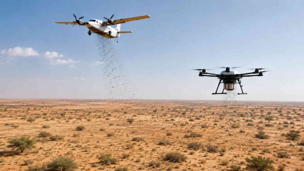
The Environment Agency, Abu Dhabi (EAD) is dispersing 10 million native seeds across the emirate’s deserts. Aircraft and drones do the spreading, not people on the ground. Artificial intelligence and satellite mapping decide exactly where each batch lands. Years of heat, sand and grazing have thinned out native vegetation in parts of the desert, and this project is meant to put some of that back at a scale manual planting could never reach on its own.
WHO IS This Project For?
This mainly affects three types of readers. People living near the seeding sites. Residents and researchers who track how the UAE handles desertification. And anyone curious about AI being used for real conservation work instead of research papers.
WHO WILL NOTICE THE BIGGEST IMPACT?
Anyone based near Al Shuwayb, Sweihan, Nahil, Al Hayer or Al Rawdah will notice the effects directly. So will visitors to Al Ghada Nature Reserve and the Houbara Protected Area in Al Dhafra. It also matters if you follow UAE climate policy, or work anywhere in environmental science.
WHAT Exactly Is Abu Dhabi Doing?
EAD is spreading 10 million native seeds by aircraft and drone over degraded desert land. Hassan Ali Al Ahbabi, a Plant Genetic Resources Centre Specialist at the Agency, calls it part of a wider effort to rebuild habitats and bring back vegetation that has thinned out in several areas over time.
THE SIX NATIVE SPECIES BEING PLANTED
Six native species make up the mix: Ghaf, Samar, Arta, Shoua, Raghal and Thamam. Where each one goes depends on the site. Soil type matters. So does salinity. So does whatever is already growing there, because a plant that thrives in one patch of desert can struggle just a short distance away.
HOW Does Aerial Seeding Actually Work?
The process runs through six stages. Seeds get collected first, only from verified native sources. They get cleaned and sorted next. Lab testing comes after that: germination rates and viability get checked before anything leaves the ground.
FROM SEED COLLECTION TO DRONE DEPLOYMENT
Many seeds are coated in natural protective pellets at this point. The coating holds moisture. It keeps birds off. It carries a bit of nutrition through the first weeks in the ground. After that, the seeds go onto aircraft or drones. Digital mapping systems guide the drop onto coordinates mapped out ahead of time.
HOW Does Abu Dhabi Decide Where to Drop the Seeds?
Site selection runs on data, not guesswork. Satellite imagery shows what’s already growing on a site. AI models take that data and estimate the odds a seed will actually take root there. GIS mapping fills in the terrain details. Rainfall analysis flags spots likely to get enough water.
HOW AI IDENTIFIES THE BEST LOCATIONS
Soil gets checked too: salinity, texture, depth, moisture retention. Slope matters as well. Seeds dropped on an incline can wash away in a flash flood. Areas under heavy grazing get skipped. Protected land that EAD can actually monitor, similar to desert areas like Al Wathba Long Salt Lake, gets priority.
WHY Use AI and Drones Instead of Planting by Hand?
Desert ecosystems in Abu Dhabi face several ongoing pressures: low rainfall, extreme heat, sand encroachment, overgrazing, a decline in native vegetation in some areas. Native plants help hold these ecosystems together. They stabilise soil. They reduce erosion. They support wildlife. Covering thousands of square kilometres of desert through manual planting would take a very large workforce and a long time to finish.
HOW AI MAKES DESERT RESTORATION FASTER
Aircraft and drones cover that ground much faster. AI decides where the effort should actually go. EAD applies tools such as NDVI and SAVI, both vegetation indexes that read plant health from satellite imagery. Together they build maps precise enough for individual seed drops. Abu Dhabi runs similar AI-based monitoring elsewhere too, including the AI centre that tracks the emirate’s waterways.
WHAT Happens After the Seeds Land?
Monitoring continues for up to two years after dispersal. EAD combines drone surveys with field visits to track germination, seedling growth, and how well vegetation establishes at each site. New vegetation maps are compared against data collected before seeding, and locations that underperform get reseeded rather than left alone.
Rainfall plays a large role in these outcomes. That’s part of why rainfall data factors so heavily into site selection to begin with. Checking current UAE weather conditions gives a general sense of the rain these sites depend on to germinate.
WHAT Results Does Abu Dhabi Expect?
EAD expects several things from this work. Soil that holds together better. Fewer sandstorms. Cleaner air. More habitat for native wildlife. More carbon stored in the ground over time. Ecosystems that cope better with climate stress.
None of that shows up quickly. Germination and habitat recovery take seasons, sometimes years, which is why the monitoring period runs as long as it does.
HOW Does This Fit Into the UAE’s Bigger Climate Picture?
This programme sits inside a bigger national approach built around nature-based solutions. The idea is simple: restoring ecosystems is one of the most direct ways to deal with climate change and protect biodiversity.
It also lines up with the UAE’s recent environmental record. The country ranked first among Arab nations in the 2026 Environmental Performance Index, and programmes like this aerial seeding effort contribute to that outcome. Drones, satellite data and AI now show up across several of Abu Dhabi’s environmental initiatives. Much of this work used to depend on field teams alone.
Frequently Asked Questions
What is Abu Dhabi’s 10 million seed project?
An EAD programme that scatters 10 million native seeds across Abu Dhabi’s deserts using aircraft and drones. The goal is straightforward: get vegetation growing back at scale.
Which native plants does Abu Dhabi use for desert restoration?
Ghaf, Samar, Arta, Shoua, Raghal and Thamam. The choice for each site depends on soil and salinity. What’s already growing there matters too.
How does aerial seeding actually work?
Seeds get collected, cleaned and lab-tested first. Many are then coated in protective pellets. From there they go onto aircraft or drones, which drop them onto mapped coordinates.
How does AI help with desert restoration in Abu Dhabi?
It reads satellite imagery and vegetation data such as NDVI and SAVI to work out where seeds are likely to actually grow. That’s how EAD picks sites instead of guessing.
Where in Abu Dhabi is the seeding taking place?
Al Shuwayb, Sweihan, Nahil, Al Hayer and Al Rawdah. Plus parts of Al Ghada Nature Reserve and the Houbara Protected Area in Al Dhafra.
How long does Abu Dhabi monitor the seeded sites?
Two years. Drone surveys and field checks track how well things are growing, and EAD reseeds wherever they aren’t.
Why doesn’t Abu Dhabi just plant the seeds by hand?
Scale. Thousands of square kilometres of desert would need a workforce nobody has. Drones and aircraft get it done faster, and AI picks the spots worth seeding.